DRIVING the DEMPSTER HIGHWAY
My brother Tom & his wife Peggy arrived in Whitehorse, from Ottawa on August 8th. They rented a truck camper and were planning on travelling around Yukon with us for a few weeks. That same night, our sister Lianne phoned to tell us that our mother in Ottawa had become critically ill. We were scheduled to be on the Dempster Highway August 11th or 12th. Because of our mother's poor health, we changed our travel plans, stayed near Whitehorse for a couple of days and arranged return flights to Ottawa on August 11th.
Had we begun that Dempster drive as originally intended, we wouldn't have made it back to Ottawa. We would have been stranded and isolated by a series of road closures; all caused by heavy rains and flood conditions that washed the road out in several locations along the first 275 kms or so. And, we would have probably missed our mothers' funeral ...
Sometimes fate intervenes; but in this case, I believe it was ... MOTHER.
Road closures along the Dempster on August 12th ...


August 17
Mother passed away and is now at peace. Following her burial, Tom and I returned to Whitehorse after a week in Ontario. Helen and Peggy picked us up at the airport and we began to make plans to drive a part of the Dempster Highway. It had taken road crews nearly a week to repair the damage at several of the locations and stranded vehicles were once again able to travel.
Based on the road condition reports we were hearing, we anticipated driving as far as Tombstone Territorial Park or possibly a bit further ... we drove further!
~
The JOE HENRY Highway
The Dempster (Joe Henry) Highway is the only road in Canada that crosses the Arctic Circle; a man made structure that meets some of the most desolate landscape on the planet. Locally, it is often referred to as “The Joe Henry” in honour of aboriginal Joe Henry, who was instrumental as a guide and scout in its construction. The highway passes through the traditional lands of his Hwëch’in peoples.
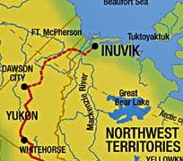
The highway was officially opened on August 18, 1979, at Flat Creek, Yukon. It was unveiled as a two-lane, gravel-surfaced, all-weather road that runs 740 km from the Klondike Highway at Dempster Corners near Dawson City to Fort McPherson, Arctic Red River and currently terminates at Inuvik in the Northwest Territories.

In 1971, after three years of hard work, the Ogilvy River Bridge was completed by 3 Field Squadron, RCE from CFB Chilliwack, BC. Later in 1977, the same unit completed the more challenging Eagle River Bridge. Ferries handle the traffic at the Peel River crossing near Fort McPherson and the Arctic Red River crossing near Tsiigehtchic.

We have made this trip seven times now and we never tire of the landscape. We haven't always completed the drive all the way to Inuvik; sometimes becoming stranded for a few days due to a weather front that made driving conditions dangerous or in this case, running out of time. We drove 405 kms; slightly more than half of the highways length. We hope to return once again in 2018 when the section from Inuvik to Tuktoyaktuk is completed.
The following series of photos is in order, from the start of the Dempster to the Arctic Circle ...


ARCTIC CIRCLE
Scientists define the Arctic as " The region above the Arctic Circle ", an imaginary line that circles the globe at approximately 66° 33' N. The Arctic Circle marks the latitude above which the sun does not set on the summer solstice and does not rise on the winter solstice. At the North Pole, the sun rises once each year and sets once each year: there are six months of continuous daylight and six months of continuous night. At lower latitudes, but north of the Arctic Circle, the duration of continuous day and night are shorter. (Source: Internet)
We did some easy hiking at the Arctic Circle, Tombstone Park and near Engineer Creek and we fished at the Engineer Creek and Ogilvie River bridges (without success). We were joined, for a couple of days by Thomas Schilling from Germany. Thomas is on a one year Truck Camper Expedition across Canada, then to Inuvik, NWT and the Arctic Circle crossing on Alaska's Dalton Highway. He then plans on overlanding south through the USA and Central America, as far as Panama. It was wonderful to meet up with him and travel together for awhile. We first made contact with Thomas through the Canadian Truck Camper Owners Group Facebook Page.
 Arctic Circle Background


Thomas Tom Peggy Helen Dann


If Rough Road Travel interests you go to our Featuring ROADS LESS TRAVELLED page on this websites' horizontal menu bar ...

That's LOAF in the dust ... Blackstone Uplands, Dempster Highway ... heading south.
If you enjoyed this report and want to read about and view photo galleries of our previous adventures along the Dempster Highway ... then click here.
If you enjoyed this report and want to read about and view photo galleries of our previous adventures along the Dempster Highway ... then click here.
Crusty ...

No comments:
Post a Comment
Your comments, suggestions, observations and even opinions are welcome ... please leave some!