OFFICIAL NAME
Yukon Highway 9 and Boundary Spur Road
LOCATION
Yukon, CANADA & Alaska, USAYukon Highway 9 and Boundary Spur Road
LOCATION
ROUTE DESCRIPTION
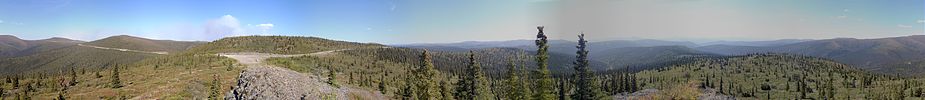
The Top of the World Highway is a 127 kilometre (79 miles) long highway, beginning at a junction with the Taylor Highway near Jack Wade, Alaska travelling east to it's terminus at the ferry terminal in Dawson City, Yukon. The highway has been in existence since 1855 and is only open during the summer months. The Alaska portion of the highway is short and not numbered. It is one of the most northerly highways in the world.
This is a narrow, winding road with steep grades and few guardrails, soft shoulders, loose gravel and washboard.
The Poker Creek - Little Gold Creek Border Crossing features one of the few jointly built single building custom ports of entry along the Canada - USA border


More Photos Here ...
...
You may also want to read about our multi-year, all-time favourite, rough road to drive, the ...
Dempster Highway
...
You may also want to read about our multi-year, all-time favourite, rough road to drive, the ...
Dempster Highway

No comments:
Post a Comment
Your comments, suggestions, observations and even opinions are welcome ... please leave some!