This is our eighth drive on the DEMPSTER Highway
It will be our first drive on the new INUVIK to TUKTOYAKTUK Highway
 |
| Engineers Creek |
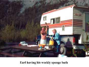
Helen's parents first introduced us to the Dempster Highway on a road trip in 1988. We were enamored with the landscape and remoteness of the region then and we still are today ... thanks Mae and Earl!
Since that time, we have traveled north of latitude 60 degrees, to Canada's Territories a dozen times. We have explored both the Arctic Mainland on canoeing, rafting and hiking trips and have been to Baffin Island in the eastern Arctic Islands on a backpacking expedition. Of the 8 drives completed, we have only made it to Inuvik at the end of the Dempster Highway 4 times (when the tractor trailer drivers hunker down you know it's time to stay put). Treacherous road conditions north-bound out of Eagle Plains delayed us for 2 days once; eventually we aborted that drive and headed south. Interesting to note that our only hazardous conditions this time were along that same stretch of roadway, this time a southbound descent to the Eagle River. Another time, family responsibilities back home in Ontario caused us to leave early and we only reached the Arctic Circle and on others, we just didn't have the time to make the complete journey.
WE ALWAYS RETURN
_____________________________
Backlinks
Reference Material
The Milepost
Our Collected Information
Our Archived Photography
Companions
Canadian Truck Camper Owners Group (CTCOG) facebook members on the drive included: Patty & Andrew, Peggy & Tom, DM (Donna-Marie) & Bryan, Katherine & Boyd and Helen & Dann.
Google Map
Dempster Corner to Inuvik to Tuktoyaktuk
Click on any of the links if you would like to learn more.
Photos
Click once on any photo and a gallery of all photos can be displayed in full screen by scrolling through.
Photos
Click once on any photo and a gallery of all photos can be displayed in full screen by scrolling through.
The Milepost
Our Collected Information
Our Archived Photography
Companions
Canadian Truck Camper Owners Group (CTCOG) facebook members on the drive included: Patty & Andrew, Peggy & Tom, DM (Donna-Marie) & Bryan, Katherine & Boyd and Helen & Dann.
Google Map
Dempster Corner to Inuvik to Tuktoyaktuk

____________________
The DEMPSTER Highway
____________________
The DEMPSTER Highway
____________________
____________
NORTHBOUND
NORTHBOUND
DAY 1
(Dawson City to) Dempsters Corner, Yukon Territory to Engineers Creek
Daily / Cumulative Distance (kms): 228.8 / 228.8
(Note: The Dempster begins 40 kms outside Dawson City at Dempsters Corner)
Travelling Notes: Low 7C, high 14C, light rain, overcast, not much road traffic, poor road conditions just south of Tombstone TP, light traffic
 |
| The Entrance to the Dempster Highway l to r: Andrew Patty Peggy Tom Helen |
 |
| km 79: View from the North Fork Pass Summit (elev. 4593 ft, high point on the Dempster). Views of the North Klondike River and the Tombstone Range in the distance. |
 |
| km 91: The Blackstone Uplands stretch from North Fork Pass to Chapman Lake. |


 |
| km 153: Northbound descent from Windy Pass Summit at elev 3478 feet |

 |
| Windy Pass Summit |
 |
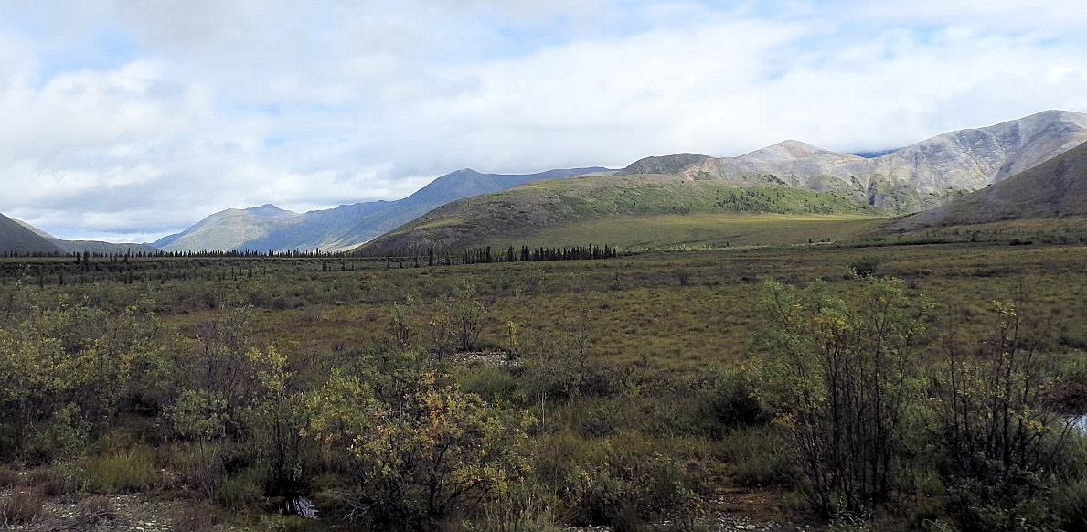
| The start of the Northern Ogilvie Mountains. Nicknamed the Limestone Hills, dolomite rock outcroppings eroded by wind and weather and rocky rubble slopes are typical. |

 |
| km 161: Engineer Creek is a tributary of the Ogilvie River. Iron oxide, limestone, gypsum, salt and sulfide bearing sediments dissolve in rain water and colour the creek and earth in reds and orange brown hues. |
DAY 2
Engineers Creek to Rock River
Daily / Cumulative Distance (kms): 246.8 / 475.6
Travelling Notes: Some wind overnight, low 8C, high 16C, overcast and quite cool, speed ranged between 40 - 60 km/h (low 20 km/h), drive got high today and the road surface deteriorated somewhat north of Eagle Plains, several washouts, snow visible in the Richardson Mountains, pickup truck overturned near campground entrance


 |
| Camping at Engineer Creek Yukon Campgrounds are inexpensive ($12/night in 2018), provide dry camping (no water, electric or dumping), are usually well-maintained with clean toilets and provide free firewood. |
 |
| km 224: Last views of the Ogilvie Mountains northbound. |
 |
| km 244: Road narrows in places as the highway climbs Seven Mile Hill, the escarpment of the Eagle Plains Plateau. |
 |
| Leaning into the wind ... |


 |
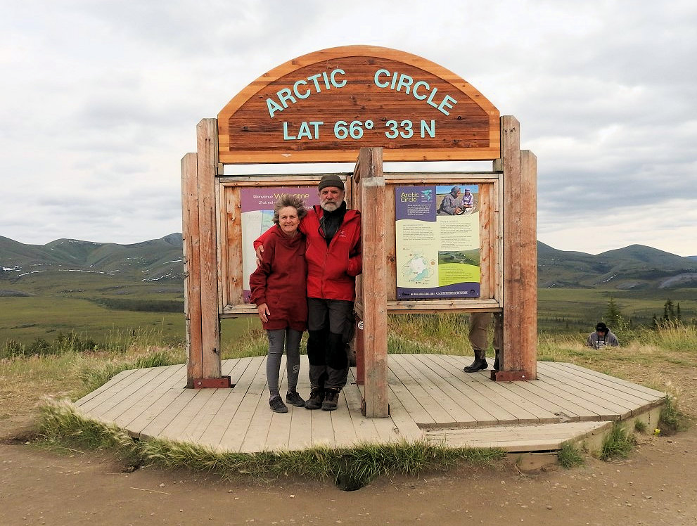
| This is one of the few un-glaciated areas in Canada with a landscape shaped by wind and water rather than by erosion. km 405: Arctic Circle Crossing Mae & Helen 1988 |

Us ... 30 years later
 |
 |
| km 280: Highway climbs northbound. |
 |
| km 287: A casualty of the Dempster Highway just before the entrance to Rock River Campground |
DAY 3
Rock River to Happy Valley, Inuvik, Northwest Territories
Rock River to Happy Valley, Inuvik, Northwest Territories
Daily / Cumulative Distance (kms): 288.0 / 763.6
Travelling Notes: This is August 17th and it's our 44th wedding anniversary, rained heavy most of the night, ferried across the Peel and Mackenzie Rivers, last section of Yukon road south of Inuvik quite rough, Inuvik marks the end of the Dempster Highway, LOAF covered with Dempster MUD
Communities
Fort McPherson: Fort McPherson (Gwich’in language: Teet'lit Zheh at the head of the waters) is a hamlet located in the Inuvik Region of the Northwest Territories, Canada. It is located on the east bank of the Peel River and is 121 km (75 mi) south of Inuvik on the Dempster Highway. The two principal languages spoken are Gwich'in and English. Originally the site of a Hudson's Bay Company post the community was named for Murdoch McPherson.
Tsiigehtchic: (/ˈtsiːɡɛtʃɪk/ TSEE-getch-ik; "mouth of the iron river"), officially the Charter Community of Tsiigehtchic,[2] is a Gwich’in community located at the confluence of the Mackenzie and the Arctic Red River, in the Inuvik Region of the Northwest Territories, Canada. The community was formerly known as Arctic Red River, until 1 April 1994.
Inuvik: /ɪˈnuːvɪk/ (place of man) is a town in the Northwest Territories of Canada and is the administrative centre for the Inuvik Region. The population as of the 2016 Census was 3,243. In 2012 the Government of the Northwest Territories reported that the population was 3,321.


 |
| km 269: Northbound ascent to Wright Pass, heavy fog through the pass and on our return, no photos.
Click here for an accident that happened just ahead of us. Extremely high, gusty winds and an inferior tie-down system on a top-heavy camper was the cause.
|
 |
| km 539: Peel River Ferry Crossing. A double-ended cable ferry, the CF Abraham Francis. |

 |
| km 607: The Mackenzie River Ferry Crossing with Tsiigehtchic (formerly Arctic Red River) in the distance. |
 |
| km 700: Approaching Inuvik. |
 |
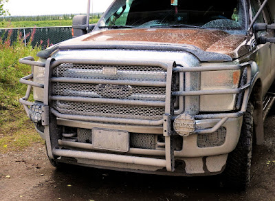
| Dempster Dirt |

_________________________________________
The INUVIK to TUKTOYAKTUK (Tuktuuyaqtuq) Road
_________________________________________
The INUVIK to TUKTOYAKTUK (Tuktuuyaqtuq) Road
_________________________________________
DAY 4
Happy Valley, Inuvik to Tuktoyaktuk Hamlet Park
Happy Valley, Inuvik to Tuktoyaktuk Hamlet Park
Daily / Cumulative Distance (kms): 160.9 / 924.5
Travelling Notes: 5C in morning, away by 9 am, some rough sections in the first 30 kms or so, after that road was quite good, rolling terrain with many small lakes, locals picking berries and fishing for trout and whitefish as we passed by, camped adjacent to the Arctic Ocean, tundra swans, gray geese (Local name - yellow legs (juvenile snow geese)), snow geese (Local name - white waveys)
Communities
Tuktuuyaqtuq: Tuktoyaktuk English: /tʌktəˈjæktʌk/, or Tuktuyaaqtuuq IPA: [təktujaːqtuːq] (Inuvialuktun: it looks like a caribou),is an Inuvialuit hamlet located in the Inuvik Region of the Northwest Territories, Canada, at the northern terminus of the Inuvik-Tuktoyaktuk Highway. Commonly referred to simply by its first syllable, Tuk /tʌk/, the settlement lies north of the Arctic Circle on the shore of the Arctic Ocean, and is the only community in Canada on the Arctic Ocean that is connected to the rest of Canada by road. Formerly known as Port Brabant, the community was renamed in 1950 and was the first place in Canada to revert to the traditional Indigenous name.


 |
| A qamutiik, (komatik) Is a sled designed to travel on snow and ice, built using traditional Inuit design techniques. Adapted to the arctic sea ice environment, sleds are still widely used in the 21st century for travel in Arctic regions. |
 |
| Arctic Cotton Eriophorum callitrix, commonly known as Arctic cotton, Arctic cottongrass, suputi, or pualunnguat in Inuktitut, is a perennial Arctic plant in the Cyperaceae family. It is one of the most widespread flowering plants in the northern hemisphere and tundra regions. |

 |
| Snow Geese The snow goose (Anser caerulescens), consisting of both a white phase and blue phase (blue goose), is a North American species of goose commonly collectively referred to as "light geese". |
 |
| Pingo A pingo, also called a hydrolaccolith,is a mound of earth-covered ice found in the Arctic and subarctic that can reach up to 70 metres (230 ft) in height and up to 600 m (2,000 ft) in diameter. The term originated as the Inuvialuktun word for a small hill. The plural form is "pingos". The term is also used for depressions, often water filled, formed by the melting of ice at the end of the last glaciation. |
 |
| Scenes around the Hamlet of Tuktoyaktuk |


 |
| Sod House before covering ... |
 |
| Sod House ... after covering |


 |
| LOAF has made it to all 3 oceans now! |

 |
| 1988: Our first trip north we flew to Tuktoyaktuk |
 |
| Team Four Degrees Tom Peg Boyd Katherine Dann Helen DM Bryan  |

 |
| Photo: Andrew |
 |
| The best places are always at ... the End of the Road (Photo: Andrew) |

____________
SOUTHBOUND
The drive south got a bit foggy, rainy, sloppy and muddy at times but we did manage to take a few photos of locations along the way to fill in some gaps.
DAY 5
Tuktoyaktuk Hamlet Park to Happy Valley, Inuvik
Daily / Cumulative Distance (kms): 150.3 / 1074.8
Travelling Notes: Rained heavy overnight, still lots of waterfowl, also sandhill cranes today, the caribou hunters are out, traffic increased on the return drive and we are noticing a colour change


 |
| ... a bit muddy |
DAY 6
Happy Valley, Inuvik to Eagle Plains, Yukon
Daily / Cumulative Distance (kms): 357.4 / 1432.2
Travelling Notes: Return ferry crossings on the Mackenzie and Peel Rivers, many bald eagles at ferry shoreline landing, in general the NWT roads have been much better than Yukon roads, extremely muddy and slippery on the southbound descent to the Eagle River, truck in the ditch there, overall there have been more cyclists than motorcyclists on the drive, saw blue grouse, rabbits, falcons, bald eagles, we had heavy fog both ways through Wright Pass


 |
| Steep descent southbound to the Mackenzie River Ferry Crossing |
 |
| km 607: Mackenzie River Ferry Crossing, Tsiigehtchic in background |
 |
| Bald Eagles at the southbound ferry landing: 4 Adults, 6 Juveniles |


 |
km 465: Wright Pass was still heavily fogged in ... as we climbed. |


km 354: The only treacherous part of the drive was the southbound descent to the Eagle River. The mud got slicker and deeper as we rounded the corner. It's a couple of kilometres down ... if 6 tons gets sliding sideways on a downgrade inertia takes over, stay center, 5 - 10 km/hr, bull low, 4x4, limited slip front, locking rear axle. One truck in the ditch and we heard that other vehicles went off later in the day.
DAY 7
Eagle Plains to Dawson City
Eagle Plains to Dawson City
Daily / Round Trip Distance (kms): 399.4 / 1831.6
Travelling Notes: At least 75 vehicles northbound as we headed out, some rain and fog in places, road mostly good south of Eagle Plains, rough sections south of Tombstone TP had been repaired, beautiful cross (red) fox near the end of the road


 |
| km 640 The Blackstone Uplands ... on a clear day. |
 |
| The Blackstone River |


 |
| km 660: Mt Tombstone in the fog in the distance. |
 |
| Almost the end of the return drive... and the mud! |
_________
Want More?
If you enjoyed this post you may be interested in reading a page that documents our trips from previous drives or viewing this compilation gallery that includes all our photos.
__________________________________________________________

We're LOAFin Around
... follow along, if you like.
Our latest route is included on TRAVELMAP 2018.

We're LOAFin Around
... follow along, if you like.
Our latest route is included on TRAVELMAP 2018.
TEAM: LOAF, Crumby,Wry and Crusty ...
__________________________________________________________

No comments:
Post a Comment
Your comments, suggestions, observations and even opinions are welcome ... please leave some!