We're
fortunate to be located within a few hundred kilometres of the southern
end of Lake Huron's, Georgian Bay. We've looked at the
maps and decided on a short road trip that
circumnavigates the bay. Once there, we'll have camping access to a
couple of national parks, several provincial ones and a few conservation
areas and historical sites. Any one of those spots feature a
combination of cultural, paddling, hiking and cycling opportunities ...
and if the weather co-operates, all the activities we enjoy!
" Georgian Bay is a large bay of Lake Huron about 190 kilometres long by 80 kilometres wide and located entirely within Ontario, Canada. The main body of the bay lies east of the Bruce Peninsula and Manitoulin Island. To its northwest is the North Channel. The Main Channel separates the Bruce Peninsula from Manitoulin Island and connects Georgian Bay to the rest of Lake Huron. It covers approximately 15,000 square kilometres has more than 30,000 islands and 2,000 kilometres of shoreline ... windswept pines, majestic towering cliffs, endless beaches and clear blue water ... "
" Georgian Bay is a large bay of Lake Huron about 190 kilometres long by 80 kilometres wide and located entirely within Ontario, Canada. The main body of the bay lies east of the Bruce Peninsula and Manitoulin Island. To its northwest is the North Channel. The Main Channel separates the Bruce Peninsula from Manitoulin Island and connects Georgian Bay to the rest of Lake Huron. It covers approximately 15,000 square kilometres has more than 30,000 islands and 2,000 kilometres of shoreline ... windswept pines, majestic towering cliffs, endless beaches and clear blue water ... "
_________________________________________________________
PETERBOROUGH LIFT LOCKS
Couldn't have asked for a nicer day; a good start to this road trip. We were mostly packed last night, only needed to load the fresh food and stock the refrigerator. A bright, sunny day, away by 9:30 am, not much traffic, stayed on secondary highways, maximum speed around 100 km/h, checked into a campsite by 3:00 pm.
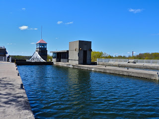
On our way through Peterborough we stopped at the Peterborough Lift Locks, an opportunity to visit another Canadian National Historic Site, this one is on the Trent - Severn Waterway.
" ... completed in 1904 and able to lift boats to a height of nearly 66 feet, this is still the World's Highest Hydraulic Lift. The lock operates on a gravitational balance system (no power is used) moving water between two chambers (caissons), lifting and lowering vessels simultaneously that are travelling in opposite directions ... "
Photos
... show the upper and lower opposing caisson chambers and one of the the huge hydraulic columns. There is a single lane pass-through below the locks, today modern width vehicles barely fit!
Our first trip to this region was in 1997. We've canoed, kayaked, hiked and backpacked at several locations over the years, but this is the first time we'll be driving completely around.
Helen in 2001 during a sea-kayak training course.
BRUCE PENINSULA NATIONAL PARK
We spent several days in the area and camped at both the National Park and in the town of Tobermory. A main draw to the region is the Bruce Peninsula Backpacking Trail that winds along the coast for 885 kms, between the towns of Niagara and Tobermory.
On our first full day here we hiked a loop out of the Birches Campground that included sections of the Cyprus Lake, Marr Lk., Bruce and Horse Lake trails (Top Rt). On other days, we walked the loop around Cyprus Lake, the trails from the Park visitor centre that include the Tower to Dunks Bay and the Burnt Point Loop (Top Lt) trails and the Singing Sands trail in Dorcas Bay (Bot Rt). We were able to hike all trails the Park offers, with the exception of those on Flowerpot Island (water taxi required), and a short cut trail near the Bruce Trail.
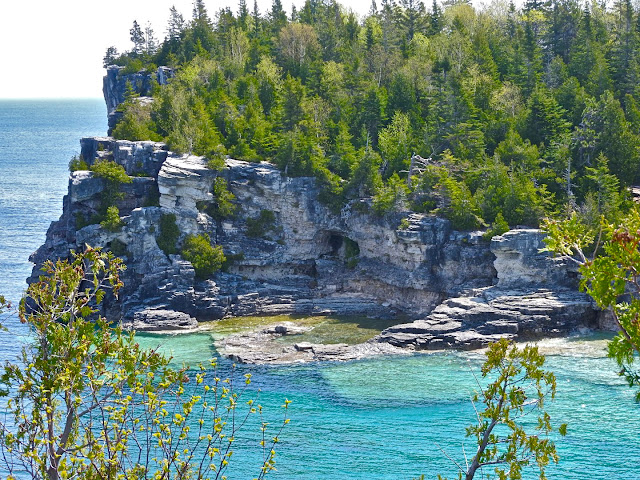
In general, conditions on all these trails ranged from easy to difficult. There are a few short, steep grade staircase areas to negotiate, some loose rock rubble along the beaches and the smooth rock along forested sections can get slippery in places. The Cyprus Lk loop is easy, flat with some rooty and rocky sections. The Burnt Point Loop gets it's rating of difficult, from the rocky trail and shoreline sections, there is very little grade change. The Singing Sands Trail is really just a walk and is mostly along an old farm road that breaks out to the shoreline near it's end. The Bruce Trail portion along the coast is difficult in places; beautiful views, limestone geology, rocky outcroppings, some erratics, torquoise shoreline waters.
Photos
MANITOULIN ISLAND
The MS-Chi-Cheemaun (Big Canoe in Ojibwe) sails between Tobermory on the Bruce Peninsula and South Baymouth on Manitoulin Island.
Vehicles enter at the bow and drive forward. It's normally about a 2 hour sail, but ... apparently, ' for the first time in 40 years the stern exit gate would not open '.
The ferry was forced to turn around and the centre lanes (large vehicles, RV's, trailers) including us and LOAF, backed out through the bow gate. Once cleared this allowed the other lanes to drive forward to exit. Exciting, all told we were only about 45 minutes late.
Photos
The Cove Island Lighthouse ... last one before the really big water of Georgian Bay.
 It may appear otherwise but this is us backing out. The boarding parking lot behind was re-arranged, to allow for large and long vehicles to manoeuver and exit.
A final photo as we leave the island ... Bridal Veil Falls (35' high); a viewpoint along the Kagawong River.
The rain has been heavy the last couple of days and it's not letting up. We're heading back to the mainland and the East Shore of Georgian Bay. We've been told it might be drier and warmer over there!
Follow us by clicking TRAVEL MAP 2017
Click on any photo (some stock) in the post to launch a slideshow gallery of all the photos.
Wikipedia may provide some content.
Crusty & Wry ...
_________________________________________________________


No comments:
Post a Comment
Your comments, suggestions, observations and even opinions are welcome ... please leave some!